
Updates Entry
November 3, 2011
Nov. 8 Big Muddy Speaker Series in Rocheport
"The People of the River's Mouth - In Search of the Missouria Indians"
presentation by Mike Dickey, Author and Site Administrator of Arrow Rock State Historic Site
Few people know that the Missouri River, and the state named after it, were actually named for a tribe of Native Americans that lived along the river near the mouth of the Grand River. Even fewer people know much about the tribe, which had already begun to decline due to disease by the time European explorers began to encounter them.
Mike Dickey will be sharing the knowledge he gained researching his recently released book called "The People of the River's Mouth - In Search of the Missouria Indians".
7:00 p.m. - Tues. Nov. 8, 2011
lower floor of the
Les Bourgeois Vineyards Bistro
in Rocheport, MO
(directions below)
Presentation is FREE! Click here for flier (pdf)
Come early to purchase a great dinner upstairs at the Bistro!
The Missouria tribe is now headquartered in Red Rock, Oklahoma, but their homeland is along the Missouri River. They called themselves "Nyut-achi", or the "People of the River's Mouth" (probably referring to the Grand River), but history knows them as the "Missouria" (from the Algonquin name for the tribe - meaing "people of the big canoes").
These people were intimately tied to the Missouri River, and lived both along its banks and in a scattering of villages in mid-Missouri (especially today's Saline County). They would follow the Grand River north to hunt for bison then return to their villages along the Big Muddy. Today's Van Meter State Park is the location of a historic Missouria (and Oneonta before them) village.

We are lucky to have Mike Dickey, the author of the most recent book collecting the story of the Missouria Indians. Come and learn about the people who our state is named for.
You can purchase Dickey's book by clicking here-
Directions
- Take I-70 to the Rocheport, MO, exit (Exit #115). It's the first exit east of the Missouri River.
- Head north toward Rocheport.
- After about a mile, turn left at the sign for Les Bourgeois Bistro. Follow the signs to the Bistro. You will probably need to park in the lot above the Bistro and walk the trail down.
- The presentations are held in the lower level. You can either enter
at the restaurant entrance then go down the stairs to your left past the
bar, or you can follow the walk to the right of the restaurant and
enter through a glass door into the lower level.
- 14020 W. Hwy BB, Rocheport, MO (click for Google Map)
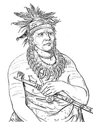
drawing on top by George Catlin (1836). Painting courtesy of Mo. Dept. of Natural Resources.
Watch This Presentation
Jodi Pfefferkorn of Flaming Fiddle Productions filmed Mike Dickey's presentation. It is available in 6 parts on YouTube. Check it out!
The Big Muddy Speakers Series in Rocheport
is hosted by Missouri River Relief, Friends of Big Muddy, the Big Muddy National Fish & Wildlife Refuge and the Columbia Fish & Wildlife Conservation Office (USFWS) with the following list of partners. All speakers are presenting for free. Thank you for sharing your knowledge with all of us!
Click here for a list of upcoming presentations»
Series Partners
Missouri River Relief
Friends of Big Muddy
Columbia Fish & Wildlife Conservation Office (USFWS)
Les Bourgeois Vineyards
Big Muddy National Fish & Wildlife Refuge
Missouri Dept. of Natural Resources
Resources
- Nov. 8 Presentation flier (pdf)
- Van Meter State Park website
- Purchase "People of the River's Mouth" by Mike Dickey
- Mo. DNR info on Missouria Indians
- Otoe-Missouria Tribe homepage
- Missouria Links

The seal of the Otoe-Missouria Tribe
www.riverrelief.org is created and maintained by Missouri River Relief, P.O. Box 463, Columbia, MO 65205
Copyright © 2024 Missouri River Relief, photos copyright © their respective owners
Site designed and built by Josh Nichols.