
Updates Entry
December 5, 2014
Missouri River MegaScout
The MegaScout online interactive map shows lots of info on the trash in the Lower Missouri River.
An interactive map of the trash on the Missouri River
The Missouri River MegaScout is an ongoing project by Missouri River Relief volunteers to map the trash on the Lower Missouri River.
The latest MegaScout Project is an interactive trash map utilizing Google Maps. Check it out at megascout.riverrelief.org Scroll down for tips on how to use the map.
MegaScout on the River
The project began in 2006 with the first MegaScout. Over the course of weeks in July and three fall weekends, two boats proceeded down the Missouri River, cataloging and rating the trash along the shores - one boat following each bank. Dumps, accumulations and large items were GPSed, photos were taken when possible, large floatable objects were "tagged" with the rivermile and date and each mile of the river was rated from 1-5 on the "Trashiness" scale.
This data was collected in a GIS database by Daniel Belshe and was used in planning clean-ups and communicating the problem of "non-point-source" solid waste on the Missouri River.
Click here to check out the MegaScout Blog, a journal of the trip.
Aerial MegaScout
In 2011, utilizing a Patagonia grant and a collaboration with EcoFlight, we did an aerial scout of the river from Kansas City to St. Charles, shooting photos of accumulations of driftwood and trash from the air. Click here for more info and links.
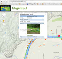
MegaScout Online Map
In 2013, Missouri River Relief subcontractors Josh Nichols and Dyan Pursell used funding from a Missouri Dept. of Conservation Fish Kills grant to put data from both scouts online utilizing Google Maps. Check out the maps at megascout.riverrelief.org
How to use the map -
- The map is based on Google Maps, so you can use the standard Google tools to navigate, including the "hand" tool to move up and down the river and the sliding zoom tool on the left to zoom in and out.
- Select data layers to display by checking the box next to the title.
- Aerial Photos (2011)- These are shown by red dots that represent where the plane was when the photo was taken. We have attempted to reflect what the photo actually shows in the title.
- Solid Waste (2006)- These are displayed by orange triangles with exclamation points. Click on these to display original data collected at this location in 2006. Some of these are also associated with photos.
- Trash Rank (2006)- Each mile was rated for "trashiness". This is displayed by a color coded line on each bank. Click the line segment for more info on the rating. 0=light blue; 1=dark blue; 2=green; 3=orange; 4=red; 5=magenta.
- Wing dikes - Will display rock structures in the river.
- Revetments - Will display rock structures on the bank.
- Boat Access - Will display private and public boat ramps and river accesses.
- Nav. Beacon - Will display Coast Guard navigation signs.
- Rivermiles - A blue dot. You need to click it to see what mile that represents.
MegaScout Quick Links
- Checkout the online map at megascout.riverrelief.org
- MegaScout Blog - a journal of our original 2006 trash mapping journey from Ponca, NE to the Mississippi River.
- 4 page document about 2006 MegaScout.
Video
- "Missouri River MegaScout" - video by Jim Karpowicz and Charlotte Overby about the 2006 MegaScout.
- "Tracking the Trash" - video by Tom Newcomb for the Mo. Dept. of Conservation "Missouri Outdoors" program.
MegaScout in the News
- "Group to scour 750 miles of the Missouri River for trash" - Sioux City Journal, July 13, 2006.
- "Flight over Missouri River to scout and map trash accumulations" - KOMU Channel 8, March 11, 2011
- "Conservation Group Plans to Clean Banks of the Missouri River" - KSHB 41 - March 12, 2011
- "Cleanup group goes to the air to map Missouri River trash" - St. Louis Post-Dispatch, March 23, 2011
Sponsors
![]()
![]()
![]()
![]()
www.riverrelief.org is created and maintained by Missouri River Relief, P.O. Box 463, Columbia, MO 65205
Copyright © 2024 Missouri River Relief, photos copyright © their respective owners
Site designed and built by Josh Nichols.