
Updates Entry
June 4, 2012
June 12 Big Muddy Speaker Series - Rocheport 2012
"The Great Flood of 2011"
presented by Doug Latka, US Army Corps of Engineers, Missouri River Water Management Division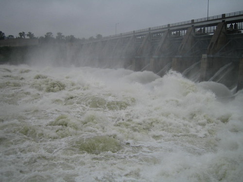
The Missouri River flood of 2011 was created by a pile of unprecedented circumstances. And it was the first major flood in the reaches of river immediately below the reservoirs since they were built. Releases from the dams stayed at 160,000 cfs for most of the summer, more than twice what the Corps of Engineers had ever released before.
The devastation from the flood continues to impact the daily lives of thousands of people living along the river. Many people, from bottomland farmers to US Senators are attempting to understand what happened, what can prevent such an event in the future and, by extension, how should Missouri River management be changed?

US Corps of Engineers biologist Doug Latka will join us to describe how the flood unfolded, why the Corps made the decisions they made and what lessons were learned that might affect Missouri River water management going forward.
Tuesday, June 12, 2012
7 p.m. presentation
lower floor of the Les Bourgeois Vineyards Bistro
in Rocheport, MO (directions below)
Click here for flier (pdf)»
Presentation is FREE and open to the public! Come early to purchase a great dinner upstairs at the Bistro!
top photo: Gavin's Point Dam at 160,000 cfs (photographer unknown). Bottom photo: Decatur area, photo by Lee Valley Auction.
 Doug Latka has been a biologist for 22 years with the US Army Corps of Engineers - Missouri River Water Management Division, which is in charge of the Missouri River mainstem reservoir system. He has 31 years of federal experience in water resources management impacts to river ecosystems. During the Flood of 2011, he was involved in flood forecasting, reservoir releases and informing the public and partners of the changing situation as it unfolded.
Directions
- Take I-70 to the Rocheport, MO, exit (Exit #115). It's the first exit east of the Missouri River.
- Head north toward Rocheport.
- After about a mile, turn left at the sign for Les Bourgeois Bistro. Follow the signs to the Bistro. You will probably need to park in the lot above the Bistro and walk the trail down.
- The presentations are held in the lower level. You can either enter at the restaurant entrance then go down the stairs to your left past the bar, or you can follow the walk to the right of the restaurant and enter through a glass door into the lower level.
- 14020 W. Hwy BB, Rocheport, MO (click for Google Map)
www.riverrelief.org is created and maintained by Missouri River Relief, P.O. Box 463, Columbia, MO 65205
Copyright © 2024 Missouri River Relief, photos copyright © their respective owners
Site designed and built by Josh Nichols.