
Updates Entry
July 5, 2011
July 12 Big Muddy Speaker Series
"The Secret Life of Sturgeon"
 Tracking and studying the rare and endangered pallid sturgeon in the massive, muddy water of the Missouri River is not an easy task. Emily Pherigo, a biologist working with the US Geological Survey will be describing some of the innovative techniques and technologies they use as they study the fish, its habitat and its behavior. This is the second in our two-part series on the pallid sturgeon recovery efforts.
7:00 p.m. - Tues. July 12, 2011
lower floor of the
Les Bourgeois Vineyards Bistro
in Rocheport, MO
(directions below)
Presentation is FREE! Click here for flier (pdf)
Come early to purchase a great dinner upstairs at the Bistro!
Join us for our monthly Big Muddy Speaker Series at the Les Bourgeois Bistro.
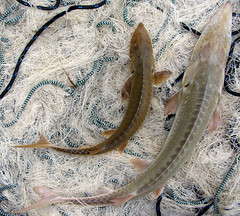
 The federally endangered pallid sturgeon has become a living symbol of the old, natural Missouri River struggling to survive in the new river we've created. This odd looking, prehistoric fish only lives in the Missouri River and the Mississippi River below St. Louis. It's uniquely adapted to the intense environment of this turbid, sandy and free-flowing river.
(photo on right: colored dots show paths of different sturgeon accessing the slower waters of Lisbon Chute as they travel upstream to spawn. The fish hit the "closing structure" at the upstream end of the chute and cannot travel further)
Which all makes this fish extremely difficult to study. Emily Pherigo, biologist working with the US Geological Survey River Studies Branch in Columbia, will run through some of the innovative methods USGS is using to reveal the habitat needs and life cycles of this rare and elusive fish. ![]()
From Didson sonar video to telemetric tracking, USGS has been fleshing out the picture of what these fish need to successfully spawn, and what obstacles they run into on our modern Missouri River. In the process, she will give the audience a unique and surprising view of the bottom of the Big Muddy.
Photo on right: USGS biologists track the path of a sturgeon heading upstream. The rainbow colored cross-section of the river on the bottom shows different velocities of that section of the river. Sturgeon tend to choose the some of the slowest water in the channel for moving upstream. This map is from the Yellowstone River.
Photos courtesy of USGS.
Directions
- Take I-70 to the Rocheport, MO, exit (Exit #115). It's the first exit east of the Missouri River.
- Head north toward Rocheport.
- After about a mile, turn left at the sign for Les Bourgeois Bistro. Follow the signs to the Bistro. You will probably need to park in the lot above the Bistro and walk the trail down.
- The presentations are held in the lower level. You can either enter
at the restaurant entrance then go down the stairs to your left past the
bar, or you can follow the walk to the right of the restaurant and
enter through a glass door into the lower level.
- 14020 W. Hwy BB, Rocheport, MO (click for Google Map)
www.riverrelief.org is created and maintained by Missouri River Relief, P.O. Box 463, Columbia, MO 65205
Copyright © 2024 Missouri River Relief, photos copyright © their respective owners
Site designed and built by Josh Nichols.